
A Day Trip to See Waterfalls
Char agreed to let me hijack her for 12 hours and we set out on a new adventure. We were in the car by 6:40 am with lunch, snacks and water packed in the cooler. Hats, mitts, warm clothes, and micro spikes were packed in our winter bag. In the pitch black of early November, we headed towards Banff on the TransCanada highway.
Fun Fact: The main route of the TransCanada Highway, is 7,821 km in length and travels through all ten provinces. It starts in Victoria, British Columbia and goes to St. John’s, Newfoundland and Labrador.
There was a good chance we would stop in the National Park for pictures or to use a roadside turnout, so I purchased an annual Park Pass the day before at AMA (a perk of membership).

When we first entered the mountains, they appeared as black one-dimensional blocks. Daybreak saw the rock faces gain definition. By the time we were to Lake Louise the mountains ranges were backlit with a pink sky and the sun shone on the highest snow-capped peaks. A breathtaking start to our day.
Our Route
We turned north on the #93 highway to Jasper. At this point, I told Char our destination: Siffleur Falls. Neither of us had been there before but we heard the falls were impressive. Char loves the roar of a good waterfall, so this seemed a perfect escape from the city.
To get to Siffleur Falls you drive the #93 highway north until you cross the Saskatchewan River and then you turn on the #11 highway. We were concerned about the conditions we would face because the #93 was snowy, icy, and it was hard to discern the marks on the road. Fortunately, we were able to follow a truck in front of us. We did have clear skies, but the wind was blowing the snow across the highway.
And then, like magic, at the bottom of a hill near the Saskatchewan River, the road became clear and dry. No other snow in sight. We turned right onto the #11 highway that takes you to Nordegg and onward to Rocky Mountain House.

This is a gorgeous drive. We love seeing new mountain ranges. Siffleur Fall staging area is 20 kilometres up the road.
Trip tip: The Siffleur Falls sign is not easy to see. The sign has several other things noted on it. If you pass a large parking lot on the right side of the road and reach a “historic landmark” pullout, you’ve gone too far. Turn back to that big parking lot. That’s the Siffleur Falls staging area.
Siffleur Falls
Siffleur Falls is an approximate seven-kilometre hike to the falls and back. Expect to take roughly two and a half hours to complete it. This largely depends on your fitness level and how many times you stop to take pictures.
From the Siffleur staging area you follow a wide path to a suspension bridge that crosses the Saskatchewan River. There was a persistent cool wind blowing through this river valley but the scenery around us was spectacular. Just what the doctor ordered!

Crossing this bridge reminded me of a much smaller bridge that used to be at the Calgary Zoo. Every step you take moves the bridge. The more people on the bridge, the more rolling the experience.

The snow-capped mountains, crisp blue sky and rushing water was just what we were looking for. Back to nature!

A short distance after the suspension bridge is a wooden boardwalk across an ecologically sensitive area. Enjoy the scenery around you and the ease of walking on even ground here. Once the boardwalk ends the trail takes on several different looks.

It is not recommended to take a stroller with small children on this trail. The path becomes rocky with many roots sticking out. It would be easy to twist an ankle or trip and fall if you don’t constantly watch where you are stepping. For those less sure footed, a walking stick could be helpful.

There is a 100m elevation gain on this hike. We discovered this is largely in one area where a narrow gravel path snakes up a steep incline (not wide enough for a stroller). From bottom to top this is a cardio workout. Your lungs and butt will feel it. Keep going, this climb is worth it.

As you weave through the trail, stop often to look around. It’s the safest way to see the forest around you.

We were lucky that there had been no snow or ice on the trail. The conditions were dry.
We understood this to be a popular trail. When we arrived just before 10am, there was only one other car at the staging area (parking lot). Near the top of the trail, we saw two people on their way back down. They were the only people we saw until we were descending the trail. A real treat.
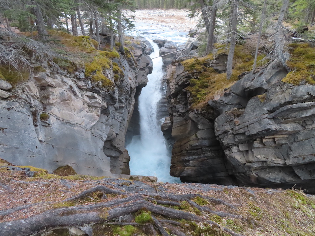
Platforms are built and permanent fencing in place to keep visitors safe while viewing the spectacular scenery.
There are three platforms, so keep going! There is a bit of a scramble up and then a small descent to the top of the falls.

There’s nothing quite like the roar of a waterfall.

The power behind the churning water.

The way that it transforms rock.

This is nature at its best.

This is what fills us and keeps us going.

So much beauty.

We were satisfied on our descent. That 100m elevation gain up, meant careful small steps down. If you’re not used to this length of a hike, take it slow so you don’t trip on the way back. There are a LOT of stones and tree roots!
Groups of people were streaming up the trail when we were halfway down. We loved that our early morning start netted us the place to ourselves.
There are two more falls beyond where we finished, however we didn’t have the time (or leg strength) for an additional eight kilometres.
We completed the hike in 2 hours 40 minutes. We had lunch in our vehicle (the wind was too cold to sit outside) and decided to do a full loop back to Calgary via the #11 highway through Rocky Mountain House.
Crescent Falls
What made this decision easy was another set of falls, Crescent Falls, was 37 minutes up the highway and we were now going that direction home!
Crescent Falls are stunning. Thankfully, after the seven kilometres we had already done, we had less than a kilometre to see them.

It was colder here. The ice on the river and over the falls attest to this.

At Crescent Falls the walking path has been closed and people are discouraged from climbing the fence. A sign near the platform at the top of the falls reminds everyone to not climb down to the falls, that deaths have occurred here, that cell service is spotty and that hypothermia can set in quickly. That all sounds like fair warning to me!

We enjoyed the beauty of this new place and headed home.

Trip tip: We fueled up in Calgary. Just across the highway from the turnoff for Crescent Falls there is a gas station. The next one after that is in Nordegg, 27 kilometres away.
We were thrilled that we decided to do a full loop and head back to Calgary through Rocky Mountain House. The drive along the Cline River was spectacular!
We fell in love with the colour of the water.

And the sweeping beauty all around us.

David Thompson Country is stunning!

We were home fifteen minutes shy of the 12 hour day I had predicted. Our bodies were tired but our hearts and minds were rejuvenated by all the beauty and fresh air.
Hats off to another amazing Krausnick Adventure!